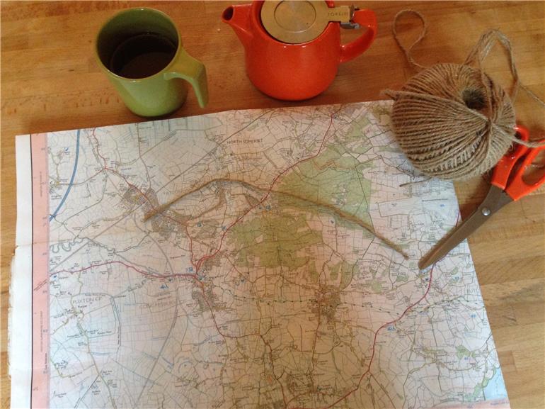
Im planning my 10 miles on the trails on Sunday and im carefully working out my route and distance ( the string is 5 miles as im doing there and back). I got lost last Sunday and im worried I'll do the same again as I have an appalling sense of direction and all the trails look the same!
Any top tips on how I can do this differently/ better without not exploring altogether for fear of getting lost?!!
Thankyou
Julia
Written by
ju-ju-
Graduate10
To view profiles and participate in discussions please or .
Hi JJ if your going to do lots of trail running look into buying a garmin forerunner 205. eBay may have cheaper 2nd hand ones. This has a get you home function which will retrace your steps as well as heart rate. Miles etc.
I use one quite a lot on the biking trails just in case I go off for an adventure lol
WOW! Look at your proper grown up map and everything! And a ball of string. I'm the same as you with directions - totally sh** at them. I reckon JAse44 has the right solution - get a garmin that brings you home. take care and do NOT get lost!
You COULD always take a loaf with you and leave a trail of bread crumbs as you ran.... No , wait, Hansel and Gretel tried that , the birds ate them , and they ended up at the ' Wicked Witch's house'....
So at least that method gets you home.... Ha ha ha ha ( ok my attempt at an evil laugh , pathetic I know)
Me and hubby did a bit of hiking last year and we started using an app called view ranger. We only used the free version but there were a lot of free loop trail walks around and then you download it to your phone. Android or apple and then you can access the app when you are out and the gps will not only tell you where you are but it has the route as well so you can see if your off course, I think you can input your own routes too. It might be worth getting used to something like that with your love of outdoors. Happy panthering.
Juicy -- perhaps you could use OPENSTREETMAP? For example, open this up in your PC openstreetmap.org/#map=16/5... and zoom in and out to places that you may want to run. OPENSTREETMAP in a crowd sourced mapping system that is fairly comprehensive in the UK .
Using an ANDROID phone, I can download its worldwide maps for free into a phone App called MAPS.ME maps.me/en/home --which is also available for Apple phones. Even without phone signal, I can get GPS when using my phone with the MAPS.ME offline maps. Hence, I NEVER get lost anywhere!!
Please tell us what location you are thinking about doing some trail running and we can see how well that area is covered in OPENSTREETMAP.
If so, OPENSTREETMAP seems to show a lot of trails through that wooded area and will therefore also show on the MAP.ME free maps on an Android or Apple smartphone. I have a cheap $99 Android phone and it works fine for me for this purpose.
If you zoom in and out, you will see the forest tracks?? Do you have a smartphone??
Hi Juicy
Use a website called walkinghighlands, create an account and log into the 1/25th scale. There you will find all the paths anywhere in the UK. Click along and create your route, it will tell you how far your route is as click various points. If you want to take it further, you can get various walking satnav's, I have a satmap, fabulous device, you can then transfer your route to the satmap. I wouldn't use the satmap to run it though, its really aimed at walkers.
That is a very interesting website -- You can download a Google Earth KMZ file for the free walking tracks that they show and when you open it in Google Earth , you can see the track with 3D topography!! Wish we had things like this in OZ!!!!
Ive used a lot lot, more last year before I started running, did some great walks, you don't realsie whats on your doorstep. The satmap is a fabulous device to use it with.
I like good run guide to look at my off road routes. You are represented by a little 🏃 on the satellite image and you can move yourself along the route and it gives you your kms. You can toggle between satellite and footpath mode, which is handy if you can't quite make out the path if it's obscured by trees etc. Its a way of exploring route's without leaving the house.
You could try Maverick, JJ. It is a GPS mapping app that will show you where you are on an Open Street map, and if you programme a route in beforehand it will tell you which direction to go in. You can also track an outgoing route and then be guided home. The Open Street maps have almost as much detail as Ordnance Survey maps now.
I did tryout Maverick once -- can't remember why now but I eventually deleted it. I have been having a great success with MAPS.ME on my Android phone. It also uses OPENSTREETMAPS. Successfully navigated around the US earlier this year with it - I don't know if it navigates walking routes though - maybe it only will navigate on roads?? Google Maps will navigate walking routes - but only on those pathways that it recognises as a walking path (which aren't many!!) I don't generally use it to actually navigate with anyway - mostly just to see where the H*** I am in regard to the map in the area that I am currently.
Content on HealthUnlocked does not replace the relationship between you and doctors or other healthcare professionals nor the advice you receive from them.
Never delay seeking advice or dialling emergency services because of something that you have read on HealthUnlocked.

") or make the tea J
or make the tea J