What are the dotted lines?: Anyone here use... - Bridge to 10K

Bridge to 10K

16,330 members25,975 posts

What are the dotted lines?

Curlygurly2 profile image
Curlygurly2Graduate10
18 Replies

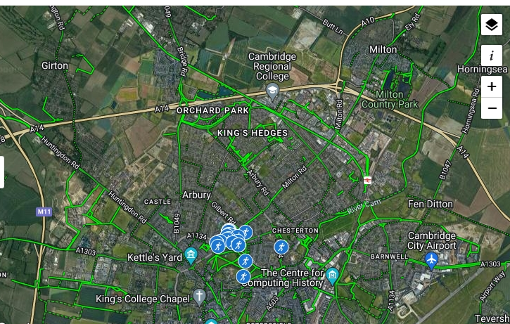
Anyone here use Garmin Connect Courses to plot, plan or measure routes? I assume the solid lines are where other people have done this, but what are the dotted lines? Yesterday I tried a route near the top of the map, above where it says Orchard Park, and was surprised to find that's a private lake and I couldn't run there...the dotty bit bottom right is my local Parkrun, so that's definitely not private...I'd have thought footpaths rather than proper roads but some dotted bits are in the town centre...

Someone please put me out of my misery!!

Written by
Curlygurly2 profile image
Curlygurly2
Graduate10
To view profiles and participate in discussions please or .
18 Replies
nowster profile image
nowsterGraduate10

It all depends on how Google Maps has classified that track, and they may have it wrong.

streetmap.co.uk/map?X=54486...

Curlygurly2 profile image
Curlygurly2Graduate10 in reply to nowster

Oh really? Thank you!

nowster profile image
nowsterGraduate10

For round Cambridge, the OpenStreetMap data is exceptionally good, but even that's unreliable for that bit around Cawcutts Lake. It shows access from the busway which doesn't show up at all in the Google Street View photos of that area.

nowster profile image
nowsterGraduate10 in reply to nowster

openstreetmap.org/#map=16/5...

Curlygurly2 profile image
Curlygurly2Graduate10 in reply to nowster

I wouldn't call it access exactly, it was just a gap in the hedge, and I had to clamber over the busway where there was no proper crossing point. I won't be doing that again...

nowster profile image
nowsterGraduate10

It can sometimes be handy to know that Bing Maps has an Ordnance Survey layer too:

bing.com/maps?cp=52.237745%...

Curlygurly2 profile image
Curlygurly2Graduate10 in reply to nowster

Thank you. Doesn't OS usually show elevation? There aren't many hills around here, but I do occasionally do hill work on Elizabeth Way Bridge, GC gives me 3 MTs total for climbing up 20 times or more!

nowster profile image
nowsterGraduate10 in reply to Curlygurly2

There are spot heights and contour lines. In the link above there's the 15m contour line.

There's a spot height of 14m in Impington itself and one of 12m just to the SW of the roundabout.

Back at the end of August last year, I did Willingham-Busway-Over-Bluntisham-Colne-Earith-Willingham as a Half Marathon route.

Curlygurly2 profile image
Curlygurly2Graduate10 in reply to nowster

Where is the spot height and contour line? Am I being dim?

Was that an organised HM or solo?

My husband has a sort of idle fantasy of working out what trajectory he would need to fire a missile from our house to land on Elizabeth Way bridge. Not to do it of course, but just to work it out....

Curlygurly2 profile image
Curlygurly2Graduate10 in reply to Curlygurly2

Ah gotcha! I can see 12...

nowster profile image
nowsterGraduate10 in reply to Curlygurly2

Solo. We were staying in Wilmington visiting a group of friends in the Chesterton area who hold an annual BBQ over the Bank Holiday weekend.

Curlygurly2 profile image
Curlygurly2Graduate10 in reply to nowster

Oh yes, I think I remember that. Not far from me, I live in Chesterton. You should let me know next time if you come, always nice to put a face to VRB s

nowster profile image
nowsterGraduate10 in reply to Curlygurly2

It's always the August Bank Holiday weekend, and they're just off Green End Lane.

(Currently looking for places to stay nearby. Prices everywhere have ballooned since last year. And I can't sleep in the car like I did when I used to come on my own.)

Curlygurly2 profile image
Curlygurly2Graduate10 in reply to nowster

I don't know what your budget is, but they have rooms above the Waterman on Mitcham's Corner, I think They include breakfast..

Curlygurly2 profile image
Curlygurly2Graduate10 in reply to Curlygurly2

Hmm, from £110, sounds a lot to me. A friend stayed at the Travelodge when she came for a race, I think that's about £60

Frenc profile image
FrencGraduate1060minGraduate

I’m afraid I can’t help Curlygurly2 but I can tell you that once, using the Footpath app, I ended up running through someone’s back garden. The app said it was a public footpath! I was mortified as the owner and his dog looked at me in a fairly angry way 🤣.

Instructor57 profile image
Instructor57Graduate10 in reply to Frenc

🤣🤣🤣

Curlygurly2 profile image
Curlygurly2Graduate10

Ha ha!! That's the sort of thing I'd do!!

You may also like...

I've done it! I signed on the dotted line.

What's that one line from a song that really speaks to you?

⭐️ NOVEMBER QUEST THE FINISH LINE ⭐️

Welcome to the Finish line of the November Quest! Or is it the Start line for December...

COGH - Getting close to the finish line

the COGH museum symbol in the map above, which is 5km from the finish line. - everyone should keep...

💥🏃‍♂️🏃🏻‍♀️ The April Quest Finish Line🏃🏻‍♀️🏃‍♂️💥