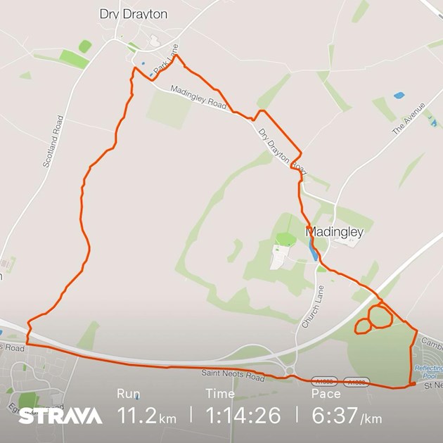
I’ve tried to stick to the plan but it’s no use! Maybe I should try measuring my new routes before I try them out? This run was easier than the last one and I went a little further. There wasn’t so much cross country, but the road section was really noisy - I much prefer the off road experience!
10k+ again: I’ve tried to stick to the plan... - Bridge to 10K
10k+ again
Written by

MadDave
To view profiles and participate in discussions please or .
7 Replies
•
sallensonGraduate10
But you did a nice sort of "acorn" thing at approx 5 o'clock, so that's good ")
mountaindreamerGraduate10
I was just going to say that perhaps if you missed out the acorn thing at about 5 o’clock then perhaps it would be nearer 10K? (Wouldn’t make such a cute route map though...) 😃🏃♂️❤️
That acorn is a figure of 8 hilly section that gets me warmed up, which is about 1/2 a mile - but you’re right I could lose that bit to shorten the route 👍
misswobbleGraduate10
Me too 😃👍🏃♂️
Langley-LoperGraduate10
I use mapometer on the computer to plan routes to find one of a suitable distance. You can either follow roads or not (or a combination on one route). Wouldn't recommend trying to use it on a phone though as screen is too small to see what you are doing.
Or you can use Strava to save routes too.
Thanks for that tip! I have tried to map routes with Strava but find it can be a bit tricky on footpaths that go across fields, especially if I’ve never walked that path before. I’ll give mapometer a go - many thanks!
That’s useful info about the route planning - I’m hovering around the bridge because I don’t know how to work out the longer routes - that sounds ridiculous now I’ve written it down!!! Need to stop being such a wuss!
Not what you're looking for?
You may also like...
Enjoyable little 10k jaunt :)
Good afternoon lovely running buddies!
I woke up this morning still with this annoying man flu...
10k hilly one and Strava fail 😤
It was quite a cool morning with a nice breeze so I decided to try a different route and go for my...
10K in the sunshine ☀️
What a lovely run this morning! After the last few miserable days it was great to see some...
Chatsworth 10k - my first official 10k :)
Well, after all the fuss, I made it round :) Thank you to all of you for your advice, support and...
It was not a fluke... ran 10Km again!
I had this sort of niggling worry that two weeks ago when I managed 10Km by surprise, that it was a...