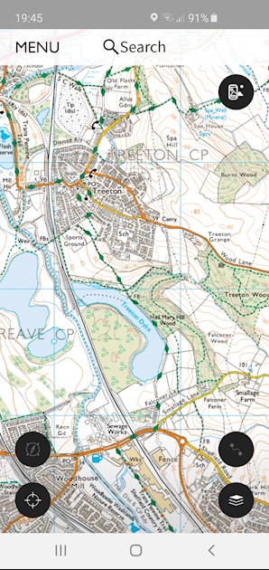
SeeJillRun if its behind the church and school there's several footpaths and bridleways that will need to be maintained...
The short green dots are footpaths, the long ones are bridleways. The only one at risk would be the one with the cross type green path, which is a by way which could turn into a road or be built over entirely. (Assuming I've got the right bit of course!) 🤣
Written by
GoGo_JoJo
Graduate10
To view profiles and participate in discussions please or .
The bit of map on your pic is too far up the hill. If you have the area to the east and a bit north, on the other side of the railway line, you should hit the right spot. To the east of the railway line there should be 2 ponds next to each other then the river to the east of them, then a larger body of water (Treeton Dyke) east of the river. That’s the river I mean, I run along the western/southwestern side, the path runs parallel to the river. Hope that all makes sense lol
Ah well, that's Treeton! 🤣🤣🤣 that bit? There's several major paths around there so they would have to retain access for those.
The ones right by the river though are not classified so could be at risk 🤔 your local planning office should have the whole development online to show what is going to result from it... again... so many lovely bits to run and explore.
Yes, that’s the right bit lol. I know I can check with the planning office but it’s in Rotherham n I don’t know Rotherham at all, I live just across the border in Sheffield. Might give them a ring n see if I can access anything online, not sure I can be bothered to get the bus into Rotherham just for that one thing lol
Thanks so much for your help though, it’s really lovely of you to take the time to look for me xx
Do check online, our planning office has everything from tree works to major developments with all associated paperwork online. 👍🏻😁 no worries, it's nice to see new areas, I'm getting to know my own too well 🤣
Yes I definitely will do, I know the plan is for 4,000+ houses, a hotel, a restaurant n some shops so I don’t hold out much hope that there’ll be much left. But I think the path may stay as it runs behind the houses further along. I can always run down to the bridge, cross the river and run round the dyke but it gets really muddy as the weather gets wetter and the path I currently run on is more like hardcore so isn’t too bad when it’s wet. Will have a look n see what’s what n let you know what I find out xx
Content on HealthUnlocked does not replace the relationship between you and doctors or other healthcare professionals nor the advice you receive from them.
Never delay seeking advice or dialling emergency services because of something that you have read on HealthUnlocked.