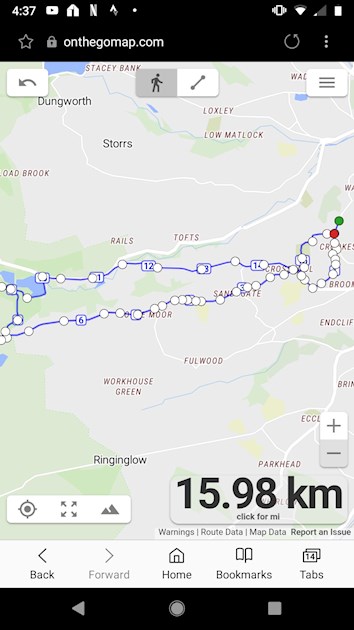
So my longest run yet(I suspect) turned out to be null and void because my £200 Garmin lost the GPS signal. Iran 7.1 km all uphill, ran down through a heavily wooded area onto the road and ran at least 5 km back. Is there anyway I can edit my run on Strava because I really need to know how far I went. My legs are telling me it certainly was the furthest I've been. What a nightmare....... The screenshot is as close as I can get the run. Thanks all for your comments.
BEYOND FURIOUS!!!!!!!: So my longest... - Fun Beyond 10K & ...
BEYOND FURIOUS!!!!!!!

On feed, goto “you”... hit the “+” top left and you can input the details. Not sure you can edit a run, but you can add and delete the erroneous one.
Strava will only record a run where there is gps. But didn’t it show the full run on Garmin Connect?
Oh No that is the worst nightmare!!!! You CAN edit on Strava. I have done this in the past when my Garmin played up. Very odd that it lost the signal thats pants 
I have a confession to make. I've looked at the spot where the GPS "lost signal" and I distinctly remember I got a bit too hot so I removed one of my tops. It may be possible I ACCIDENTALLY pressed the run button therefore pausing/stopping the run. WHAT A LEMON I AM..........
That's a great run and that's what really counts. Add it manually to strava as others have said - and put your screenshot of the route with it as a photo, then it's all there for future reference.
Thanks Linda. After many attempts I found a site that allowed me to track my run and measure the distance. The final few yards were quite painful so I think at least 2 rest days are required..
You should also be able to track (and measure) runs with Strava, Mapmyrun and Rungo. Probably lots more apps too!
In strava (on a laptop), it's under Dashboard then My Routes then Create New route. I use it a lot to work out new routes before I set out. You can follow roads/paths (and I find Strava knows about more paths than MMR in my area) or you can set it to manual and plot your own route. It calculates distance as you plot your route, and you can also check elevation too!
Taking it a step further, you can download a GPX file of the route you made in strava and import that into Rungo. Rungo is then useful for giving you directions on the move while you run, and for showing a red dot/line of where you have run which is handy if you end up off track 
You maybe didn't need to know all that .. but you never know, one day it may be handy 


You can measure it on goodrunguide too
I’ve clicked my watch off when peeling my jacket off too 🙈
the tech is more annoying than the running, that's for sure
Tell me about it. According to Strava I've never run a marathon! Remember kids - Start your watch whilst in the start pen. I was about 30m short of 42,198m somehow!
You can edit a gpx file manually and upload it wherever you like to record your runs, but it requires faffing around with coordinates and is a real pain and super time consuming to get right. It's not really worth the effort, to be honest! Especially as you'll be bashing long runs out fairly regularly from here on in 🙂